 7 Jours
 Liberté / sans guide
 Avec transport de bagages
 Classic (dormitory)
 Niveau
*
*
*
Niveau
*
*
*
 À partir de 645 €
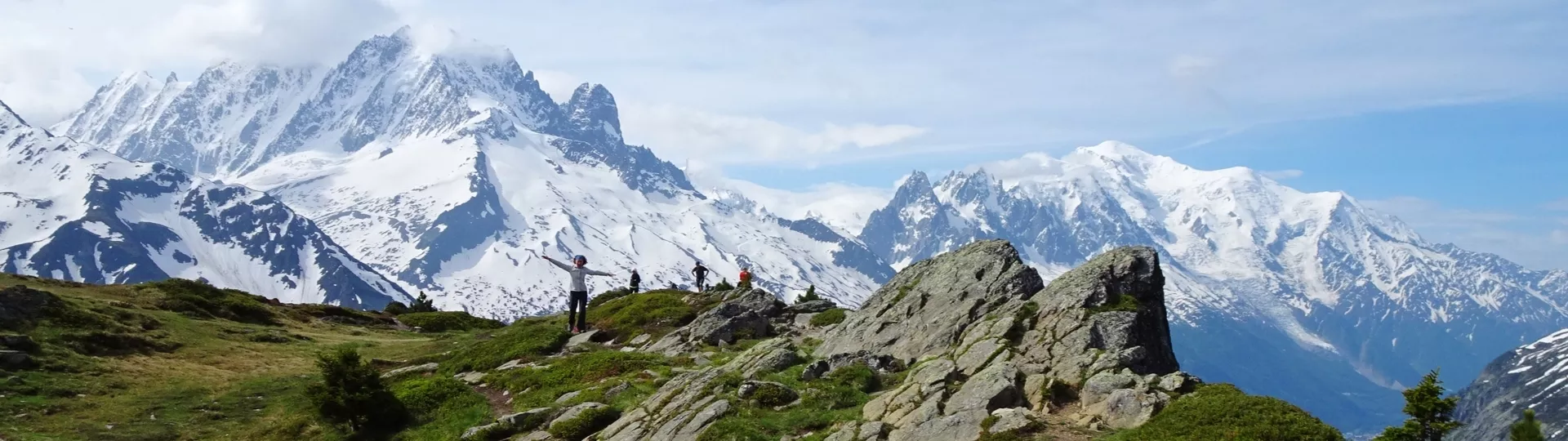
A journey at altitude
Founded in 1922, the first natural park in Italy and Europe, the Gran Paradiso National Park defines an impressive high mountain range furrowed by deep valleys. Created on the initiative of King Victor Emmanuel II to protect ibex, the park remains a safe haven and protective area for animals including: chamois, ibex, marmot, fox and vultures. We propose an unusual circuit crossing some of the finest high mountain passes between the Valgrisenche and Valsavaranche with the imposing summit of the Gran Paradiso (4061m) in view. Seven days hiking, escaping civilisation to discover a universe shared between valleys, traditional pastures and high mountain wilderness.


Vous allez aimer
- Alpine landscapes bordered by vast glaciers
- Crossing major mountain passes and pastures full of flowers
- Pastoral activity still very much alive
- Easy wildlife watching, well protected in the heart of the park
- The hospitality of Italian refuges
Circuit
Dernières minutes !
-
TOUR OF MONT BLANC 7 days
The classic...
Seven valleys, 71 glaciers, 400 summits... The Mont Blanc range is fascinatingly beautiful, like a diamond, from every a... -
TOUR OF THE MATTERHORN & BREITHORN SUMMIT (4164m)
Around the sphinx of the Alps
The Matterhorn, an elegant geological natural sculpture perched between Switzerland and Italy, is certainly the most ico...
Dates & tarifs
DEPARTURES AND PRICES
Departure from 22 June to 07 September 2025
Without luggage transfer, daily departure
Minimum 2 persons : 645€/pers. in classic accommodation
Single person supplement, without luggage tranfer: +150€
With luggage transfer (except on Day 4 and Day 6), departure on Saturday, Sunday, Monday, Tuesday
780€/pers. for a group of 2 to 6, in classic accommodation
Single person supplement, with luggage tranfer: +250€
Information and booking by telephone or email.
Réserver en ligne
THE PRICE
The price includes:
- Accommodation with half board formula from dinner of day 1 to breakfast of the last day;
- 1 road book file (paper) for your group and the digital version to download for each participant; additional paper road book on request;
- Luggage transfer, if you have chosen this option (except on Day 4 and Day 6);
- Transfer on day 3 (Bruil >> Valgrisenche);
- Tourist tax;
- Booking fees.
The price does not include:
- Lunchtime picnics;
- Personal expenses (drinks, touristic visits, etc.);
- Luggage transfer on Day 4 and Day 6;
- Return transfer Chamonix/Pont;
- Supervision by a mountain guide;
- Return journey from your home to the departure/ end point;
- Cancellation insurance.
L'itinéraire jour après jour
Departure from Pont, Valsavarenche, in the Aosta Valley.
PONT - VALLON DE MEYES - EAUX ROUSSES
Climb to the dry stone built hamlet of Paradis and Meyes then descend to the village Eaux Rousses. Night in a gite.
5 hour walk / Elevation : +700m ; -1000m / 11km
LACS DJOUAN ET NERO - COL DE L’ENTRELOR - BRUIL
Long steady climb without difficulty to Col de l’Entrelor (3023m) via the pastures and Lakes Djouan and Nero. From the mountain pass, view over the Grand Paradiso summit. Descend to Bruil village. Night in a gite.
7 hour walk / Elevation : +1300m ; -1250m / 14km
VALGRISENCHE - REFUGE DE L’EPEE - COL FENETRE
Taxi transfer in the Valgrisenche to Refuge de l’Epée. Leave your baggage at the refuge, climb to Lake Tei then to Col Fenêtre (2873m). Return to the refuge.
4 hours walk / Elevation : +850m ; -100m / 6km to the refuge ;
around 3h00 / Elevation : +/-500m / 6km from the refuge to col Fenêtre
LAKE SAN MARTINO - REFUGE BEZZI
Traverse above Valgrisenche along the balcony trail opposite the Ruitor chain of mountains. Small detour possible to Lake San Martino at 2770m. Descend to the refuge Bezzi, at the foot of the glaciers. Night in a refuge without luggage transport.
4 hours walk / Elevation : +500m ; -600m / 9km
COL BASSAC DERE - LAKE GOLLETA - REFUGE BENEVOLO OR FOND
Trek alongside the Gliairetta Glacier. Climb to the Col Bassac Déré (3083m) and descend to Lake Goletta, under the Goletta Glacier then on to the refuge Benevolo.
5 hours walk / Elevation : +800m ; -800m / 10km
COL ROSSET - LAKES CHAVANEY - LAKE NIVOLET
Cross the pastures and go up to Rosset pass (3023m). Go down to the Plateau Rosset via the lakes Chavaney and Lieta. Night in a refuge without luggage.
5 hour walk / Elevation: +850m ; -600m / 10km
VALLEY OF NIVOLET - PONT
An easy crossing through pastures opposite the snow topped Gran Paradiso summit. Descend to Pont by the "Sentier des alpagistes" trail or via the Col du Grand Collet at 2800m.
2.45 hour walk / Elevation: -550m / 8km
4.5 hour via the Grand Collet / Elevation : +400m / -1050m / 10km
End point at Pont in the afternoon.
Le voyage
LEVEL ***
Elevation: +/- 500 to 1300m average per day.
Walking time: 5 - 7 hours average per day.
Type of trek: Stony trails that take daily passes located between 2800m and 3000m altitude. Some passes are steep as well as several aerial or technical paths, mainly at the start of the season with the crossing of residual snowfields. The trails are relatively well marked except when approaching certain passes.
The route in general is well indicated, and the roadbook provided sufficiently complete to allow you to hike in complete safety. However, it is essential to be able to read an 1:25,000 map and to be sufficiently autonomous in the mountains to be able to tackle the itinerary with confidence, whatever the weather (fog, snow, etc.). Guiding is not included in the self-guided package. For your own safety, you may wish to bring along a radio or the latest generation telephone with satellite connection.
Snow and névés will be present on the paths until end of june at least. You may walk on long snowy sections that can make the tour a bit more challenging. High mountain boots, gaiters and walking poles are mandatory.
You have to be in a general good fitness level. Please practice a cardio sport such as hiking, running, cycling, from 3 to 4 hours a week.
Your physical preparation will enable you to enjoy your trek to the maximum. Be prepared! You will be crossing areas with no telephone network.
Please find the description of the levels by clicking here: levels of difficulty
ROAD BOOK
One month prior to departure, we will send you your travel documents. We offer two roadbook versions:
The "paper" version we send by post:
- 1 IGC maps (n°102),
- 1 road book with all the necessary information for the hike,
- 1 card holder
- The list of accommodation.
The "digital" version is an application to download on your smartphone, accessible to each of the participants of the file. The information for downloading and using it is sent by e-mail.
SIGNPOSTS AND WAYMARKS ALONG THE TREK
The route is marked with a yellow arrow and regular ground markings (in both directions). The trails are identified with numbers.
It is preferable to know how to read a topographical map at 1/25000.
LUGGAGE TRANSFER
Two options:
without luggage transfer: you carry all your luggage
with luggage transfer: your luggage is delivered daily (except on day 4 and day 6) at your accommodation.
ACCOMMODATION
3 nights in refuge, in dormitory
2 nights in gite, in a shared room
1 night in refuge, in a shared room.
All accommodation is equipped with hot showers. However, due to increasingly recurrent periods of drought, access to showers is not guaranteed.
MEALS
Breakfast and dinner are provided in each accommodation. Picnics are not included and can be pre-ordered at each accomodation in the evening. You can buy picnic supplies in small local shops (on day 2 in Breuil).
Please inform us about your food allergies and special diets at the time of booking. We do our best to accommodate special diets (gluten-free, vegetarian, etc.). However, we encourage you to bring some additional products for your own picnics.
MAPS
Instituto Geografico Centrale:
n°102 VALSAVARENCHE, VAL DI RHEMES, VALGRISENCHE
Infos pratiques
ACCESS TO DEPARTURE POINT
Departure from Pont, Valsavarenche.
BY TRAIN
TO AOSTA VIA TURIN OR
TO CHAMONIX VIA PARIS
Inbound: depart Gare de Lyon (Paris) the day before at 12:45pm arrive in Chamonix at 7:50pm.
Night train: depart Gare de Lyon (Paris) at 11:06pm arrive in Chamonix at 09:50am.
Return night train: depart Chamonix at 6:14pm arrive in (Paris) Gare de Lyon at 06:18am.
Times given are indicative and should be verified at a train station or at www.oui.sncf
BY BUS
VIA CHAMONIX
From Chamonix to Aosta by SAT bus.
VIA AOSTA
By Turin then Aosta. From Aosta, the Savda buses take you 3 times a day to Pont (1h30 journey).
Two successive bus lines will take you to Pont from Aosta :
1 - Line 514: Villeneuve / St-Pierre / St Nicolas
2 - Line 611: Villeneuve / Valsavarenche
BY CAR
VIA THE MONT-BLANC TUNNEL
Take the A40 motorway towards Chamonix, follow signs for Milan and take the Mont-Blanc Tunnel to Italy (58€ return) www.atmb.net
Follow signs for Courmayeur/Aosta (signed blue), then direction Introd and Valsavarenche, 3kms after the village Aviez continue to to the end of the valley to arrive in Pont.
VIA THE COL DU PETIT-SAINT-BERNARD
From the southern regions of France take the A43 motorway to Chambéry, the A30 to Albertville and follow direction Bourg St Maurice. Follow signs for Col du Petit St Bernard and Italy (a very good mountain road) passing through La Thuile to Pré St Didier. Follow signs for Aosta (signed blue), then direction Introd and Valsavarenche, 3km after the village Aviez continue to to the end of the valley to arrive in Pont.
End point at Pont, Valsavarenche.
ACCOMMODATION BEFORE AND AFTER
Chamonix : Hôtel Vallée Blanche : +33 (0)4 50 53 04 50
Tourist office Chamonix : +33 (0) 4 50 53 00 24
Hostellerie du Paradis, Eaux Rousses : +39 0165 90 59 72
Hôtel camping Grivola : +39 01 65 90 57 43
Tourist office Aoste : lovevda.it and aoste.ialpes.com
TO CONTACT US
If you are late please contact the agency as soon as possible: +33 (0)4 50 79 09 16 or +33 (0)6 42 49 76 07
Équipement et bagages
EQUIPMENT LIST
Clothing
- Walking trousers
- Shorts (Bikini/swimsuit, just in case!)
- Breathable or merino wool t-shirts
- Breathable or merino wool leggings
- Fleece or jumper
- Lightweight down jacket
- Wind stopper or Goretex jacket
- Waterproof poncho + gaiters or Goretex trousers + waterproof rucksack cover
- Pair of gloves and a warm hat
- Sun hat or baseball cap
- Walking socks (1 pair per day)
- Sturdy walking boots with a good sole, already broken in
- 1 change of clothes for the evening
- A pair of comfortable shoes for the evening
Other Equipment
- Toilet bag
- Quick drying towel
- Sunglasses and sun cream
- Water bottle or Camelback (1.5 litre minimum)
- Knife, fork and spoon
- Plastic lunch box/plate for your picnic lunches (0.40L to 0.50L)
- Plastic cup for coffee
- Small First Aid kit (antihistamine, ibuprofen, Compeed type blister pads...)
- Survival blanket
- Head torch or hand torch
- Sleeping bag liner sheet and pillowcase (blankets provided at accommodation)
- Two adjustable walking poles (highly recommended)
- Identity card or passport
BACKPACK
Bring a comfortable backpack of 30 to 40 litres for your personal belongings for the day (warm clothes, waterproofs, water, plate and cutlery for your picnic, sunscreen and your identity papers) and please keep a little room to carry a picnic and snacks.
LUGGAGE TRANSFER
You are allowed 1 soft, sports type bag, with all your possessions inside, of 10kg maximum per person. Your baggage will be transported daily, except on days 4 and 6, between accommodation by our logistics vehicle where access is not always easy.
Baggage which is too big and too heavy won't be accepted by the drivers, please think of their backs!
YOUR BACKPACK FOR NIGHTS WITHOUT LUGGAGE TRANSFER
On nights 4 and 6, you won't have your luggage at the accommodation (you'll find it the next day). Here's some advice on what to bring (around 2 kg is enough!):
- a small toilet bag
- your sheet-bag
- a change of clothes for the next day (just what you need!) and comfortable clothes/shoes for the evening.


